Coastline FAQs
Where is the shoreline?
 Photo credit: B. Isaki, O'ahu.
Hawai‘i law defines the “shoreline” as “the upper reaches of the wash of the waves, other than storm and seismic waves, at high tide during the season of the year in which the highest wash of the waves occurs, usually evidenced by the edge of vegetation growth, or the upper limit of debris left by the wash of the waves.”
Irrigating or planting vegetation in or near the beach to manipulate or alter the location of the shoreline is prohibited. The state owns all lands makai of the shoreline and these lands are in the state Conservation District.
 Photo credit: B. Isaki, 61-635 Kamehameha Highway, O‘ahu.
What is a "certified shoreline"?
A certified shoreline is a shoreline that has been staked out and surveyed by the State Surveyor. This is usually done to determine a shoreline setback for purposes of construction and also delineates the boundary between the shoreline proper - which lies in the state Conservation District - and the county’s jurisdiction over the Special Management Area. The certification is good for 12 months and may be used to develop construction plans. The shoreline is located at the mouth of harbors, lagoons, and marinas, unless there are both natural and artificial shorelines, in which case there can be multiple shorelines. For fishponds, the shoreline is along the shore and not at the fishpond wall. The state surveyor posts its site inspection schedule and pending certification applications on its website: http://ags.hawaii.gov/survey/shoreline/
 Photo credit: Kai Nishiki, Honokōwai seawall, June 2019.
However, a shoreline certified on an artificial structure, like a seawall, breakwater, or revetment, is good for the life of the structure.

Photo credit: TE Revocable Trust, Shoreline Application No. MA-753, 4680 Makena Alanui Road.
Can the public traverse across all beaches?
Mostly - except on certain beaches adjacent to military bases/ property. Elsewhere the right of lateral transit exists makai of the shoreline. “The right of access to Hawaii's shorelines includes the right of transit along the shorelines.” HRS §115-4.
 Photo credit: B. Isaki, O‘ahu.
Can shorefront landowners regulate or prohibit lateral beach access along shorelines or recognized public beach access routes?
No person can obstruct access to public spaces by installing physical impediments or other actions
intentionally prevent the public from traversing public beach access, along the beach, or other public right of way. Improper physical impediments to public access include, gates, fences, walls, barriers, rubbish, security guards, guard dogs, or human-induced, enhanced, or unmaintained vegetation that interferes or encroaches within beach transit corridors.
Shorefront landowners are prohibited from irrigating or planting vegetation to interfere with lateral transit because it obstructs access to public property, which is a misdemeanor. DLNR is authorized to require landowners to remove human-induced or unmaintained vegetation that encroaches on the beach transit corridor. HRS §115-5.
 Photo Credit: Anonymous, Grand Wailea, Kīhei, sprinkler in naupaka and drops from sprinkler on sand.
Any person who impedes lateral access across beaches through us of physical impediments such as gates, fences, guard dogs, rubbish, security guards, are subject to a minimum $1,000 fine for the first offense or $2,000 fines thereafter.
Photo Credit: Hedges obstructing fisherman’s path to the beach. Kai Nishiki, Nāpili, Maui.
Is the public required to have access to the beach?
Maui’s subdivision ordinance requires public shoreline access intervals of not greater than 1,500 feet and a minimum width of 15 feet. Maui County Code (MCC) § 18.16.210 (Ord. 789 § 1 (part), 1974). However, this requirement only applies to lands subdivided after 1974. Many coastline properties were also required to provide public beach access as a condition of their Special Management Area use permits. The HK West Maui Community Fund hosts a West Maui beach access page that includes links to county Special Management Area use permits and state Conservation District use permits.
 Photo credit: Sydney Iaukea, Nāpili, Maui.
How is public shoreline access established?
The state or county can condemn or dedicate land for public beach access purposes. Often, the county will make public access a condition of a SMA use permit granted to the coastal landowner or a grant of a subdivision approval. A public access is also already established where the public has used an access for at least twenty years continuously since 1969 or more than ten years prior to 1969, without permission from anyone, their use is widely known, and the use was not for private commercial purposes.
When do I call the county and when do I call the state DLNR?
Counties generally have responsibility over maintaining public beach access except where the public beach access trail is part of the Na Ala Hele system, which consist in historic and ancient trails or the adjacent landowner induces vegetation to grow across the beach transit corridor. HRS §115-10. The state is responsible for protecting coastal resources, which includes ensuring there is no placement of materials in the shoreline or construction taking place in the shoreline without permission through conservation district use and/or right of entry permits or easements.
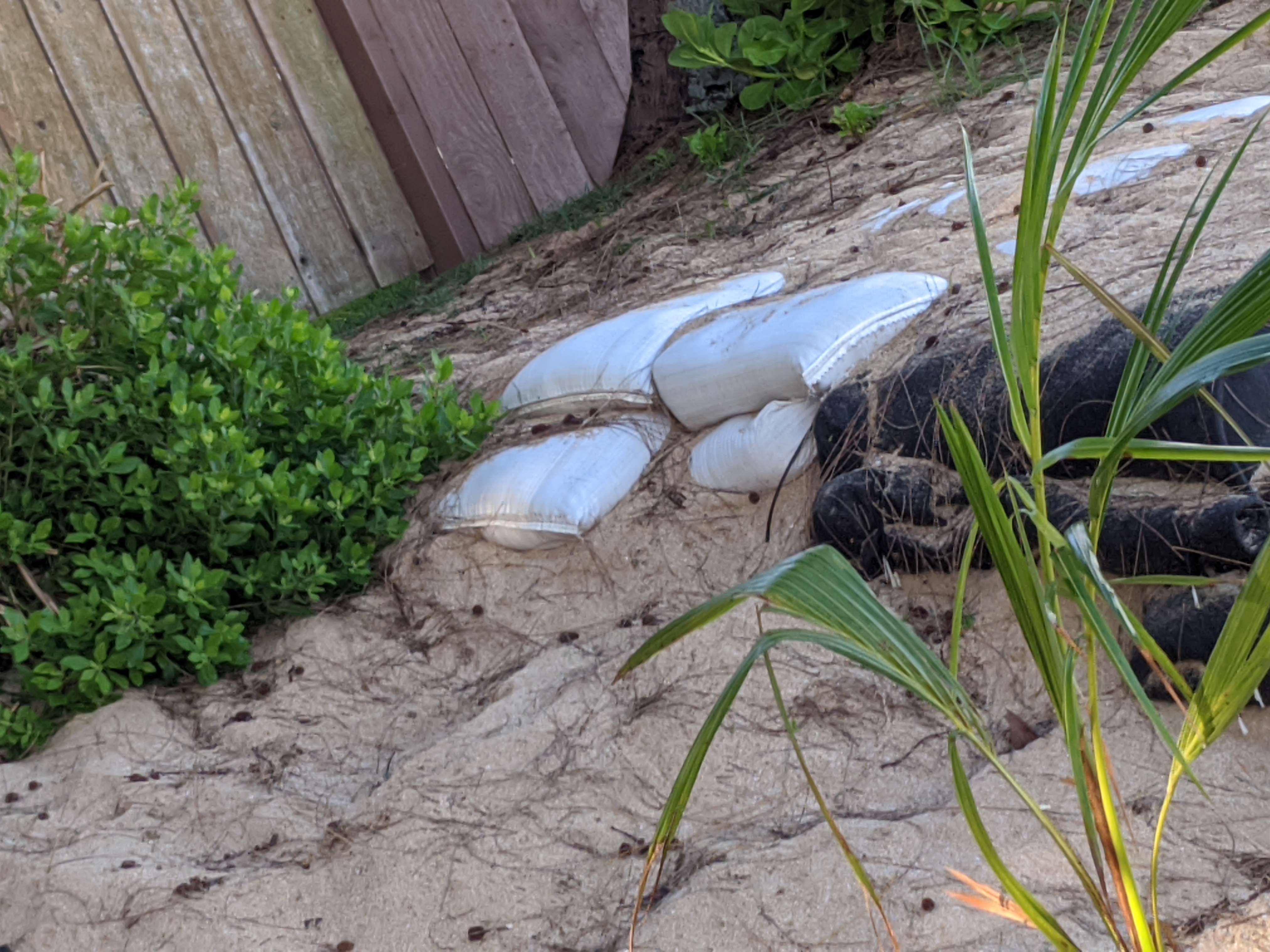 Photo credit: B. Isaki, 61-635 Kamehameha Highway, O‘ahu.
What is the Special Management Area?
The SMA must be shoreline or coastal-related land and is defined by maps filed with the Planning Commission as of June 8, 1977. The SMA Locator Online Map is searchable.

How do we know where the shoreline setback is?
The formula for calculating a shoreline setback is defined in the Maui Planning Commission’s shoreline setback rules, specifically Maui County Rule §12-203-6.
MC §12-203-6 Establishment of shoreline setback lines.
(a) All lots shall have a shoreline setback line that is the greater of the distances from the shoreline as calculated under the methods listed below or the overlay of such distances:
(i) Twenty-five feet plus a distance of fifty times the annual erosion hazard rate from the shoreline;
(ii) Based on the lot’s depth as follows:
(A) A lot with an average lot depth of one hundred feet or less shall have a shoreline setback line twenty-five feet from the shoreline;
(B) A lot with an average lot depth of more than one hundred feet but less than one hundred sixty feet shall have a shoreline setback line forty feet from the shoreline; and
(C) A lot with an average lot depth of one hundred sixty feet or more shall have a shoreline setback line located at a distance from the shoreline equal to twenty-five percent of the average lot depth, but not more than one hundred fifty feet.
(iii) For irregularly shaped lots, or where cliffs, bluffs, or other topographic features inhibit the safe measurement of boundaries and/or the shoreline, the shoreline setback line will be equivalent to twenty-five percent of the lot’s depth as determined by the Director, to a maximum of one hundred fifty feet from the shoreline.
(b) Notwithstanding any provision of this section to the contrary, a lot shall have a shoreline setback line at a distance from the shoreline that provides for the minimum buildable depth; provided that, in no case shall the shoreline setback line be less than twenty-five feet from the shoreline.
(c) Prior to commencement of grubbing, grading, or construction activities, the shoreline setback line shall be identified on the ground and posted with markers, posts, or other appropriate reference marks by a surveyor licensed in the State of Hawaii.
You can get the “annual erosion hazard rate” from the Hawai‘i Coastal Erosion Group webpage.
Shoreline violations: how to spot them, what to do, who to call?
Sandbags, bulldozers moving sand, stairs, ladders, or any other placement of material in the shoreline requires the State Department of Land and Natural Resources (DLNR) Office of Conservation and Coastal Land (OCCL) permission to use the conservation district.
DLNR is located at 1151 Punchbowl Street, Room 131, Honolulu, Hawai‘i 96813
Phone: (808) 587-0377, (808) 643-DLNR
With the inward march of our rising oceans, many of the structures that encroach on the beach may be under a special management area use permit from the County Planning Department too.

Photo credit: Kai Nishiki, Keonenui 2019.
For fences, gates, guard dogs, irrigated plants obstructing beach access, call the County Planning Department to enforce beach access, but the State to enforce laws prohibiting those structures on shoreline lands. Also, any person taking sand, shells, or other materials from the beach (besides the sand stuck to your slippers), should have a permit to do so from the Planning Department first.
The Maui Planning Department is located at 250 S. High Street, Kalana Pakui Bldg, Suite 200, Wailuku, Hawai‘i 96793 Phone: (808) 270-7735
Channeling runoff, pool water, or other pollution to the ocean is also regulated under federal permits that are administered by the state Department of Health. The DOH Clean Water Branch Office in Maui is at the Maui District Health Office, 54 High Street, Room 300, Wailuku, Hawaii 96793
Phone: (808) 873-3556.

Photo credit: Tiare Lawrence, Kahana Bay Resort pool water entering ocean, April 2021.